Saturday, September 25, 2021

Stretching the Legs

Today's flight was another in the progression of stepping further away from home plate and practicing some proper cross country navigation.  This allows for putting into practice some of the flight planning, weather briefing, and fuel management skills which don't get much airtime when flying locally.

In this case, the weather briefing and overall real-world weather couldn't have been better (or simpler).  A solid high pressure system kept not only the skies clear but the winds light and temperatures mild.  So while I went through all the steps, there wasn't much that required any special concern, or even any special fuel planning.  With no significant headwinds or tailwinds either direction, it amounted to simply multiplying the fuel burn by the expected time en route.  Similarly, there was no significant wind correction to apply, so simply flying the GPS course was sufficient to arrive at Point B.

Before departing the local field, I did a couple of touch and go's just to get into the rhythm and mentally prepare for the longer flight.  I think this might be a good practice overall, and will try to do it as much as possible, at least when flying solo.  It keeps the skills a bit fresher and adds a bit of a safety factor compared to, say, airline pilots who just hop in and fly multiple hours every day.  After not flying for even a few days, it feels a bit wrong to do that when I have no idea what lies at my destination (or even a few miles out).  Similar to venturing into shallow ocean waves before diving in, this re-acclimates my flying mind to the environment.  

Coincidentally, I decided to just do two landings before departing for the horizon.  It turns out this was a fortuitous decision, as a Cirrus in the pattern right behind me decided to blow a tire and close the runway while it was repaired.  I heard all the commotion as I was climbing out and was glad I didn't have to get into the middle of that.

One of the key decisions for this flight was choosing a cruise altitude.  I wanted to stay relatively low and below the height (3,000 AGL) which would require an FAA-dictated VFR altitude based on my direction of flight.  But I also was a bit cautious of rising terrain and the possibility of some turbulence as I crossed over a particular ridgeline midway through the flight.  I opted for flying roughly 2,500 ft AGL, which provided a nice, smooth ride.  As I approached the ridge (one I have never flown over on my own) I predicted that I would experience some rising and falling air currents.  To my surprise I was actually correct and felt the mild ups and downs about where I expected.  For the return flight, I flew just a couple of hundred feet higher since it was likely going to be a more turbulent headwind, and while I still felt the bumps, they didn't toss me around too much.


 Also on the return flight, I started noticing louder wind noise and a bit of a whistling sound.  Indeed, though my altitude hadn't changed, the airspeed had jumped up apparently due to a bit of a windshear or different flow.  I powered back and rode through it to keep the speed at about 90 knots.  But the strange whistling kept coming and going.  Maybe the wind direction was causing a strange pressure zone around the doors or air vents?  I never figured out what it was.

Returning to home base, the winds had picked up a bit, and there was what felt like a bit of thermal activity - not unexpected for a late summer afternoon.  I also had to blend in with the other traffic again.  In this case, I planned on crossing overhead and then entering a 45-degree teardrop to the downwind.  As I approached the field, I heard an inbound regional jet setting up for the opposing runway direction on a long straight-in.  I asked over the radio how long before they would be at the field and the response was "three to five minutes".  That didn't give me much time to come back around and not rush my pattern, so I announced that I would back off, exit the pattern and stay clear until they landed.  However, another plane had also entered the area, and was sort of stuck behind me.  We both ended up circling for what felt like more than five minutes while the regional jet finally made it in.  I was in the process of coming back around into a base-leg turn, but hadn't had a chance to descend from pattern altitude.  I ended up too high and too fast as I entered final, and knew I would not be making a stabilized approach - so I did a go-around.

This I think was a good decision as it allowed the other plane to come in a bit quicker (they didn't say anything, but something about the tone of their voice made it seem like they wanted to get down) - not to mention it kept me from doing something drastic just to get the plane on the ground when there was no urgency.

I did a couple more touch and go's, with a right crosswind that gave me a bit of trouble and caused my last landing to be quite a bit long.  So, more work needed there.

Since this was still a relatively short cross-country, I didn't need to do much cross checking of fuel burn and progress, but this is a key item for any longer flights in the future. 


Tuesday, September 14, 2021

Mini Cross Country

Picking up from where I left off last time, I decided on short notice to try again for a mini cross country to a few of the local fields.  Checking the weather the night before showed that it would be a beautiful day for flying, with light winds, clear skies, and much less haze and smoke than in past weeks.  I was also hoping for one of the 172s with the updated avionics to again practice some of the GPS and ADS-B In functions in real time.

When planning the route as a flight-only trip (e.g., no stops or touch and go's) the trip is estimated at just about one hour.  Knowing that I'd want to not be pressed for time and be able to just have a bit of a wander, I scheduled the plane for five hours, and ended up putting nearly three on the Hobbs meter.  This just reinforces how much extra time to allow when planning any long flight, especially for fuel stops or other diversions.

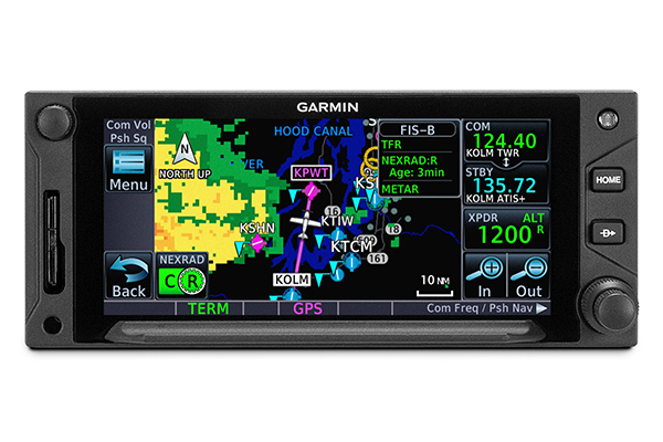
One of the key differences between any "cross country" flight and something more local is that the various waypoints or destination are beyond the visible horizon (even more so on a hazy day).  It's therefore even more important to understand navigation, engine (and fuel) management, and how to use the various tools at one's disposal to stay on course and on schedule for fuel.  In this case, the trip length would be well within the plane's fuel capacity, and I had the tanks topped off before the flight.  So while that wouldn't be an issue, I would be able to try out some of the features on the Garmin GTN650.

Compared to panel-mounted GPS units from 15 years ago, those available today have a great deal more functionality, touchscreens, and more intuitive user interfaces and menu trees.  But this means learning a whole new system even if it is coming from the same manufacturer.  For today's flight, I made sure I could work the basic radio functions, find the right navigation screen, explore the direct-to function, and experiment with flight plans. I must say - even if the features were otherwise identical, the touchscreen interface makes a world of difference and helps (me anyway) quickly switch back and forth between head-down and looking outside.  The old Garmin with menu choices driven by a twist-and-push knob had me looking inside a bit too much.

The flight itself was just fun.  Being able to navigate to unfamiliar uncontrolled fields, pick up weather along the way, enter the pattern, and practice some landings with no glideslope lighting really made this a great day.  Even though the legs between each field were short, I still was able to go through the typical profile of climb, cruise, descent, and approach with time to do the regular GUMPS check.  I even remembered to spend about 10 minutes on the right tank only, with the accompanying mental preparation for an engine failure upon switching tanks back and forth (everything was just fine however).  I also got to just putter around the sky under 3,000 feet AGL and sightsee for a bit.

Each of my three stops were deserted fields, so I would just do one or two landings and then fly on to the next.  But back at the home base, it was a busy day with other school aircraft and a few fast movers - a twin and a regional jet.  

Upon coming within about eight miles, I heard the twin report inbound as I was picking up the weather.  The winds were light, so either direction runway would have been fine for me.  I let the faster aircraft set the pace, and called them up to ask which runway they were setting up for.  When they responded back, we were able to coordinate how I would come in underneath their flight path and enter the downwind behind them.  I even threw in an S-turn to put a bit more distance between us.  

On the next pattern, I was following another school Cessna, but faster plane was also entering the pattern and ending up in front of us all.  I think the other Cessna could have just slowed a bit more, but he decided to do a 360 turn, so I (being just a mile or so behind him) also did the same.  From the ground, we probably looked like a perfectly choreographed formation flight...  The only problem with that is having to reacquire visual contact once I came out of the turn.  No worries.

Finally, on the last pattern of the day, a regional jet blasted its way in from the upwind side of the field.  I could see him coming in as I climbed out, and could also verify his location with the ADS-B In traffic display.  That's a great tool and I hope to be able to make good use of it if I'm ever in some seriously busy airspace.  Around these parts it's more of a novelty item.

All in all, this was a good confidence booster that I could manage the key aspects of the flight - controlling the airplane, navigating "cross country", managing the systems, and coordinating with other aircraft in the uncontrolled (or as some call it, "pilot controlled") airport environment.  Like so many other flights, there are things to improve on but we'll save them for next time.